SUMMARY
This is AI generated summarization, which may have errors. For context, always refer to the full article.
MANILA, Philippines (4th UPDATE) – On July 16, 1990, the Philippines was hit by one of the most devastating earthquakes in recent times. A 7.8-magnitude earthquake hit the northern part of Luzon, leaving 2,412 people dead and around US$369.6 million worth of damage to property.
The earthquake’s epicenter (marked with a star icon on the map) was located near the towns of Rizal and Bongabon in Nueva Ecija. Most of the casualties and damage, however, was recorded in the cities of Baguio (Benguet), Cabanatuan (Nueva Ecija), and Dagupan (Pangasinan).
On October 15, 2013, a magnitude 7.2 earthquake rocked Central Visayas. The epicenter was located 2 kilometers southeast of Carmen, Bohol (09.80°N, 124.20°E).
The earthquake was felt throughout the Visayas and Mindanao regions, leaving at least 28 people dead and damaging buildings and historical sites across the region, particularly in Bohol and Cebu. Both provinces have now been placed under a state of calamity. (READ: Strong quake rocks Visayas; 28 dead)
Prior to this the last strong earthquake to hit the area was a magnitude 6.5 earthquake off the coast of Bohol on February 8, 1990.
On December 15, 2019, a magnitude 6.9 quake hit Davao del Sur, killing at least 4 people. Just two months before that, in October, parts of Mindanao were hit by 4 earthquakes measuring higher than magnitude 6.0: magnitude 6.3 on October 16, magnitude 6.6 and a magnitude 6.1 aftershock on October 29, and magnitude 6.5 on October 31. All tremors had the same epicenter, Tulunan, Cotabato.
Strongest earthquakes
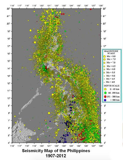
Since the 1600s, there have been around 149 earthquakes in the Philippines with a magnitude of 6.0 or higher. Of the many islands in the country, only Palawan island has not been visited by destructive earthquakes, according to a seismic map produced by the Philippine Institute of Volcanology and Seismology (Phivolcs).
The strongest recorded earthquakes that hit the Philippine archipelago occurred on Sept 20 and 21, 1897, in the Celebes sea area, between the islands of Sulu and Basilan. While no succeeding earthquakes so far matched the intensity of the July 1990 quake, it was not the strongest in Philippine history. In fact, the 7.8-magnitude record that year comes only as 7th among the strongest that have hit the country.
The Sept 20, 1897, earthquake registered a magnitude of 8.6 on the Richter scale, while the second quake, which occurred on the very same location the next day, registered a magnitude of 8.7.
Next in terms of magnitude were 3 earthquakes with a magnitude of 8.3 (Aklan in 1948; near Davao Oriental in 1924; Celebes Sea in 1918). There were 3 with a magnitude of 8.1 (west of Sultan Kudarat in 1976; east of Davao Oriental in 1943; east of Samar in 1897).
Two earthquakes with a magnitude of 8 occurred in Las Piñas in 1645 and in Cagayan in 1627. Four occurred with a magnitude of 7.9: west of Ilocos Sur in 1934; Masbate in 1897; west of Ilocos Norte in 1897; east of Samar in 1897.
Six earthquakes were as strong as the July 16, 1990 tremor, with a magnitude of 7.8: east of Surigao del Norte in 1952 and 1951; Mindoro Oriental in 1942; Surigao del Sur in 1911; Davao Oriental in 1903; Quezon in 1901.
Rappler mapped the strongest earthquakes to hit the country using seismic information dating from as far back as the 1600s, and noted around 149 that registered 6.0 or higher on the Richter scale.
The circles in the map represent the epicenters of recorded earthquakes. The darker the circle, the higher the magnitude of the earthquake.
Note: Data for the 2000s are updated to include available data from Phivolcs from 2006 to October 2008, and since 2011. Epicenters located below the 4.6ºN parallel and/or in Indonesian territory are excluded.
Ring of fire
Dr Arturo Daag of Phivolcs told Rappler that although we cannot predict the next big earthquake, some studies show that “200 years is the return period for another major earthquake in the same area.”
Nearly all the islands, as the map shows, are prone to and have been visited by earthquakes.
This is partly because the Philippines is located in the Pacific Ocean’s “Ring of Fire,” which includes about 90% of the world’s volcanoes and where a nearly continuous series of oceanic trenches and volcanic belts are situated, and plate movements occur.
The Philippines is flanked by the Manila trench and the Philippine trench, both active subduction zones.
This has implications on land use and urban planning, according to Daag.
Hazard maps should, ideally, be used to identify fault lines and areas where it is unsafe to construct buildings. This information should also determine whether or not building permits should be issued to applicants.
According to the recommendation of Phivolcs, buildings must be constructed at least 5 meters away from faults. There are no restrictions in height. An engineer should be able to determine whether or not the ground can support a building of a certain height.
Daag maintained that while Phivolcs recommends policies and measures that address earthquake preparedness and mitigation, it is up to the policymakers to approve them.
Preparedness is key

In a country prone to geological hazards, Phivolcs Director Renato Solidum stressed the importance of preparing by knowing what to do and where to go when a disaster strikes. (READ: Earthquake tips: what to do before, during and after)
He said the public should do the following in case of an earthquake:
- Stay indoors if one is already in a house or structurally-sound building
- Duck, cover, and hold on to something sturdy
- After the shaking stops, those indoors should evacuate to a safe open space
Solidum also encouraged the public to join earthquake drills and to conduct their own earthquake drills at home, in school or in the office.
On Friday, March 27, 2015, various government agencies conducted #OplanPagyanig, a nationwide simultaneous earthquake drill to test the government’s readiness to react in the event of a major quake.
The drill is in anticipation of a 7.2 magnitude earthquake that could be generated by movement of the West Valley Fault which could destroy 40% of buildings, trigger fire in various parts of the city and kill about 35,000 to 40,000 people. (WATCH: LIVE: #OplanPagyanig: National Earthquake Drill).
“Disaster Preparedness should be everybody’s business. The imagined earthquake impact scenarios can be a nightmare if we don’t prepare and take things seriously,” Solidum said. – with Mica Romulo, Reynaldo Santos Jr. and Gwen de la Cruz/Rappler.com
This story is part of a series of content on natural hazards, disaster preparedness and climate change adaptation on Project Agos, a collaborative platform that combines top-down government action with bottom-up civic engagement to help communities learn about climate change adaptation and disaster risk reduction.
The project harnesses technology and social media to ensure critical information flows to those who need it before, during, and after a disaster. It is a partnership between Rappler and key government, private and civil society groups. It is also supported by the Australian Government.
Add a comment
How does this make you feel?


There are no comments yet. Add your comment to start the conversation.